Posts

Showing posts from March, 2023

Typography

Image
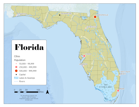
For our second module in GIS5007, we were tasked with creating a map of Florida with a requite list of features. These included county boundaries, several major cities, and a handful of important rivers. For this map, I used Esri ArcGIS Pro and a provided global database. I focused on presenting a visual hierarchy that highlighted the requisite map elements in a conventional and visually pleasing manner. For the major cities, I chose to use an ordered rank symbology with the smallest city represented with a light, small circle, the middle-sized cities with a medium size and shade, and the largest cities with the largest and darkest symbol. The capital of Tallahassee is differentiated with a small black star. Additionally, the cities are labeled in a sans-serif font to distinguish them from natural features. They also have a white shadow to aid in readability. The cities should probably have just the beginning letters capitalized as that is the more conventional type setting.  I cho...

Map Critique

Image
     For this week's lesson, we were tasked with finding, selecting, and critiquing two maps- one as an example of a "good map" and one as an example of a "bad map". We had to justify our critique by discussing the various map principles and how each map executed the various "Tufteisms". We evaluated each map's use of cartographic design in its attempt to convey substance in an aesthetically pleasing and logical way. Example of a "Good Map"     Source      For my example of a good map, I chose a cartogram from ESRI's showcase gallery. It is not a traditional map but it uses a cartogram to depict the quantity and density of breweries in countries across the world. It uses simple symbology to quickly convey data; the audience can quickly decipher where the largest quantity of breweries are located through the use of size and color. Further information is provided in smaller subtitles and subtext, which is also color-coded. The cartogram...

Welcome to GIS 5007 Spring 2023

Image
My name is Kelsey Yoder-Ostroski and I am a new(er) student in the world of GIS. This is my third class in UWF's GIS Admin graduate program as a full-time student. At the moment I am a caregiver to our kids but I also do volunteer work with a nonprofit providing support to local moms. We are a military family; we have lived in the Navarre area for 3 years and are preparing to move to Germany this summer. I'm not ready for the cold! I am originally from Texas so I love the heat, but we can't wait to see everything Germany and its neighbors have to offer.  In my free time, I enjoy learning German, baking (mostly breads), or doing home improvement projects. I have a weakness for cookies and power tools.  I am pursuing a master's in GIS business administration because I love how applicable and versatile it is. It literally encompasses every topic on Earth from the land to its resources and to all of history. I'm not 100% sure what I will do after graduating but I am int...