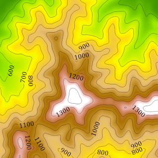
Visualizing Terrain in ArcGIS Pro

Visualizing Terrain in ArcGIS Pro Ever hear the joke about the topographic map? It was hill-arious! As stated in my last blog post, the world is not flat but traditional mapping is. So how do we go about translating 3D objects into a 2D space? Terrain visualization is the process of representing either the physical characteristics of the terrain or phenomena occurring at that location. The goal is to provide a visual and intuitive understanding of a specific area's topography and landscape features. Frequently slope and elevation, rainfall, and landcover are recorded and symbolized in various methods. By combining recorded measurements with location and elevation, we can analyze possible patterns and make more accurate predictions. Contour lines are lines on a map or a two-dimensional representation that connect points of equal elevation above a reference point, usually sea level. These lines help visualize the shape and relief of the land, indicating changes in elevation ac...

