Data Collection and Projections
Click the following link to view this week's data collection via ArcGIS Field Maps: Click Here
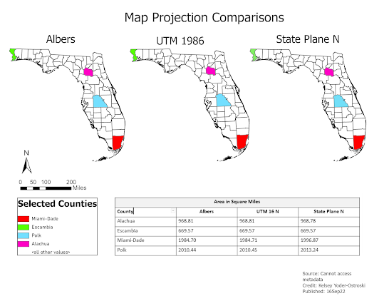
This week's lab was a massive project and, unfortunately, I do not have an accurate map to show for it. As you can see above, all three maps are using the same projection (and, thus, no comparison can be made). This week has been challenging. For the past few weeks, I had been completing schoolwork on a laptop old enough to go to school itself. I am fortunate enough to be able to upgrade to a more up-to-date system. However, I think of the students who can not afford to spend money out of pocket or have access to on-campus computer labs.
Again, my map is not accurate in the least. For reasons I have not yet discovered, my projections were lost during the transitioning to a new computer. The map is also... visually unappealing. It has the basic elements (minus the metadata that I can not access) but it has no personalization.
I need to walk away for awhile and maybe tomorrow try again.
Edited on 19Sep22
I returned to this lab several days later and I am happy to say that I have figured out why my projection layers were not retrievable and that I have a new, improved map. It seems that my .prj files where not saved to the geodatabase (they were being saved to the general project file). When I reopened ArcGIS, the program could not locate them because they were never a part of the geodatabase. I also had time to improve the appearance of the map (background colors, removal of an extraneous feature layer in the legend). Our instructor, Amber Bloechle, and graduate assistant, Brittany Joe, advised for final details. Much thanks for the help! Below is the updated map.


Comments
Post a Comment