Through Esri's online courses, users can take unlimited lessons and learn a plethora of skills. ArcGIS Pro allows users to create, explore, and analyze data with 3D visualization. Below we will explore some of these 3D visualization techniques. All screenshots are from Esri's online training program or online tutorials.
3D Visualization
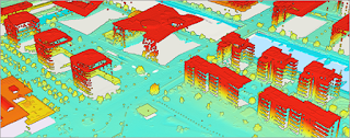
Users can manipulate 2D data by converting it to 3D, allowing more realistic visualization. 3D representation of LiDAR data is used for measuring surfaces, which can then be converted into a digital elevation model (DEM) or digital surface model (DSM).
LiDAR data
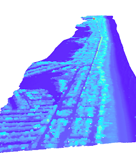
As seen in the next screenshot, the produced DEM can reveal topography not seen by the naked eye. Here we can explore the features under the surface of the water. Other applications include mapping underground utilities and resources.
An integrated mesh layer of photography or realistic textures can be draped over 3D objects to create a real-to-life representation. The analyst can also set the time of day to explore how shadows and sunlight affect the area.
Integrated mesh layer
Line of Sight and Viewshed Analysis
The images below are of a line-of-sight analysis and a viewshed analysis. Both use the same algorithm to determine areas of visibility with slightly different outputs. As the name indicates the line-of-sight analysis produces lines, which delineate rays from a point observer to a target. Green indicates the line is visible whereas red indicates an obstacle in the way.
A viewshed analysis counts the number of times a cell is visible from the observer. Below we can see a map indicating which areas are illuminated by three different spotlights. The darker the color, the more overlapping light there is. Both analyses are useful for exploring potential routes or coverages. For example, a viewshed analysis could determine optimal security camera coverage.
Sharing via ArcGIS Online
Esri allows for data sharing through ArcGIS Online. These layers can be shared with the public or within an organization, dependent on sharing privileges.


Comments
Post a Comment