Spatial Interpolation
Spatial Interpolation
Comparing Exact Interpolators
Interpolation is a fundamental concept in spatial analysis, where we aim to predict and construct new data within a range of known data points. In an ideal world, we could do field studies on every square centimeter of the Earth and collect unlimited data. Since this not (yet) possible, we can strategically plan where to collect samples and use these points to mathematically predict ground truth.
But before that, here's a joke. Did you know there are two kinds of people in the world? (1) Those who can extrapolate from incomplete data
What are Exact Interpolators?
For this analysis, we compared several methods of exact interpolation techniques. Exact interpolators are methods where functions pass through known data points. We compared the outcomes of three differing methods: Thiessen polygons, Inverse Distance Weighting (IDW), and Spline (regularized and tension). While these methods guarantee accuracy at known points, choosing the appropriate method depends on factors such as computational efficiency, smoothness requirements, and user knowledge of the study area.
Thiessen Polygons
The simplest method of interpolation is Thiessen polygons, which estimates values by assigning the value of the nearest data point. The advantage and disadvantage of Thiessen interpolation is its simplicity. Values are assigned solely on proximity without regard to spatial distribution. It is computationally efficient and useful for minimizing bias. However, as is obvious from the resulting map, there is little reflection of the real world. Boundaries are sharply defined and each area is grossly generalized.

Inverse Distance Weighting (IDW)
Inverse Distance Weighted (IDW) interpolation calculates values at unknown points by weighting the average values of nearby points. These weights are inversely proportional to distance; i.e., closer points are given more weight than those farther away.
Local influence dominates, and there are no smooth global transitions between values. These results in sharp changes between regions, jagged boundaries, and circular patterns. IDW is better suited in areas where local variation is important with dense data points.

Spline
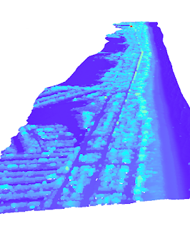
Spline interpolation produces smooth and continuous ranges, which is beneficial in areas where values change gradually. The method forces the surface to touch every sample point in the same way a rubber sheet is forced over a series of points. The resulting map avoids sharp breaks and fills in gaps more robustly than IDW.
It is important to note in DEMS, this smoothing comes at the cost of potentially losing sharp topological features such as cliffs and ravines. It can also struggle in areas of abrupt value changes, resulting in unrealistic value ranges. We can force the rubber sheet to stay closer to known sample values with a tension spline.


Regularized Spline (left) versus a Tension Spline (right)
In practice, splines are often preferred for their balance between accuracy and smoothness, especially in applications requiring the interpolation of large datasets. However, understanding the underlying principles of these techniques provides a solid foundation for tackling diverse interpolation problems in spatial analysis.
Further Reading:
Bolstad, P. (2017). GIS Fundamentals: A first text on Geographic Information Systems (5th ed.).
XanEdu ; Eider Press.
Ikechukwu, M. N., Ebinne, E., Idorenyin, U., & Raphael, N. I. (2017). Accuracy assessment and
comparative analysis of IDW, spline and Kriging in spatial interpolation of landform
(topography): An experimental study. Journal of Geographic Information System, 09(03),
354–371. https://doi.org/10.4236/jgis.2017.93022
comparative analysis of IDW, spline and Kriging in spatial interpolation of landform
(topography): An experimental study. Journal of Geographic Information System, 09(03),
354–371. https://doi.org/10.4236/jgis.2017.93022
Comments
Post a Comment