Surfaces - TINs and DEMs
Surfaces - TINs and DEMs
Triangulated Irregular Networks (TINs) and Digital Elevation Models (DEMs) provide models critical to understanding and analyzing our planet. Through ArcGIS Pro, the GIS platform developed by Esri, we can create both these model types.
Understanding TINs and DEMs
What is a TIN?
A Triangulated Irregular Network (TIN) is a vector-based surface representation, represented through the connection of elevation points. These irregular points are connected with non-overlapping triangles. The face of each triangle is interpolated for values such as slope.
TINs are effective models for representing rugged terrain while also being data light. Because values are derived from a finite number of points, the facet values are assumed. Subtle changes in the landscape are lost in exchange for efficiency.

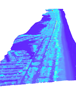
Close up of TIN model
What is a DEM?
A Digital Elevation Model (DEM) is a raster-based representation of the earth's surface, where each raster cell (also called pixel) represents an elevation value. DEMs are typically derived from satellite imagery or LiDAR. They are particularly useful in large-scale terrain analysis.

LiDAR-derived DTM of Death Valley
There are two types of DEMs:
- Digital Surface Model (DSM): Includes all objects on the surface, including buildings, roads, and vegetation.
- Digital Terrain Model (DTM): Excludes all surface objects and represents the bare earth.
DEMs provide detail that is smoothed out by TINs. However, this comes at the cost of computing.
Further Considerations
- Interpolation Methods: DEMs can be created using various interpolation methods, such as Kriging, Natural Neighbor, Radial Basis Functions (RBFs), and Inverse Distance Weighting (IDW). Each process uses a different approach to calculating values and should be applied according to available data and needs.
- Data Quality: As with all analysis, the accuracy of TINs and DEMs rely on the quality of input data. As in previous blog posts, data should be considered for completeness, accuracy, and precision.
- Projection: The appropriate projected coordinate system is essential to accurately represent distance and elevation.
- Resolution: Higher resolution lends to more accurate models. However, elevation is a continuous variable, infinitely changing throughout the terrain. The more data, the more processing power and storage required. Resolution has to be balanced with project needs.

TIN (above) vs DEM (below) of the same river valley

Further Reading:
TIN in ArcGIS Pro from EsriHow Weighted Overlay Works from Esri
Comments
Post a Comment